Kirkjubæjarklaustur - shortened to Klaustur by everyone who lives here and most who visit - is a small village of about 120 people in South Iceland, sitting between the Skaftá lava fields and the edge of Vatnajökull glacier territory. Its position on the Ring Road, roughly midway between Vík (approximately 2 hours west) and Höfn (approximately 2 hours east), makes it one of the most useful overnight stops for Ring Road travellers. It has fuel, food, accommodation, and several genuinely worthwhile natural sites within walking distance or short driving range.
Kirkjugólf - the Church Floor
A natural basalt column formation approximately 5 minutes’ walk from the village centre. Free. The tops of the basalt columns sit level with the ground, creating a flat geometric surface that looks, from above, like a tiled floor - hence the name. The Norse settlers who found it in the 9th century assumed it was a ruin of an ancient church floor; it is entirely natural. It is a small but distinctive geological feature, worth 15–20 minutes. Signposted from the main road through the village.
Systrafoss Waterfall
A double waterfall on the hillside above the village, fed by Systravatn lake. Free. The walk from the village takes approximately 15 minutes on a well-maintained path. At the top of the path you reach Systravatn lake itself - a calm, clear lake with mountain views. The round trip to the lake and back takes 30–45 minutes. Particularly photogenic in morning light when the mist from the falls catches the sun. The path can be muddy in wet weather - waterproof footwear is useful.
Systravatn Lake
Reachable via the Systrafoss path above. Free. A small lake with a peaceful atmosphere above the village. Local folklore connects it to the medieval Benedictine convent that gave the village its name (Kirkjubæjarklaustur means “church farm cloister”). The views from the lake back down over the lava plains toward the coast are worth the short climb even if you have already seen the waterfall.
Laki Craters (Lakagígar)
The most significant natural site accessible from Klaustur - and a full-day undertaking. The Laki volcanic system erupted from 1783–1784 in one of the largest volcanic events of the last 500 years, producing lava flows that covered approximately 600km² and releasing sulphurous gases that killed a significant proportion of Iceland’s livestock and caused a famine that reduced the population by approximately 20%. The crater row is now a protected area within Vatnajökull National Park.
Access is via the F206 mountain road, open approximately June–September. 4WD is mandatory - this is an F-road with rough terrain and potentially wet sections. The drive from Klaustur takes approximately 1.5–2 hours each way. From the car park, a hike to the main Laki crater peak takes approximately 45 minutes return and gives views across the entire crater row. The scale of the lava field - Eldhraun, the moss-covered lava from the 1783 eruption - becomes fully clear from the summit.
Guided tours: Available from Klaustur and Vík for approximately ISK 15,000 as of 2026. The advantage is a guide who can explain the geology and history in context. Check current operators in the village or via geopark.is.
Fjaðrárgljúfur Canyon
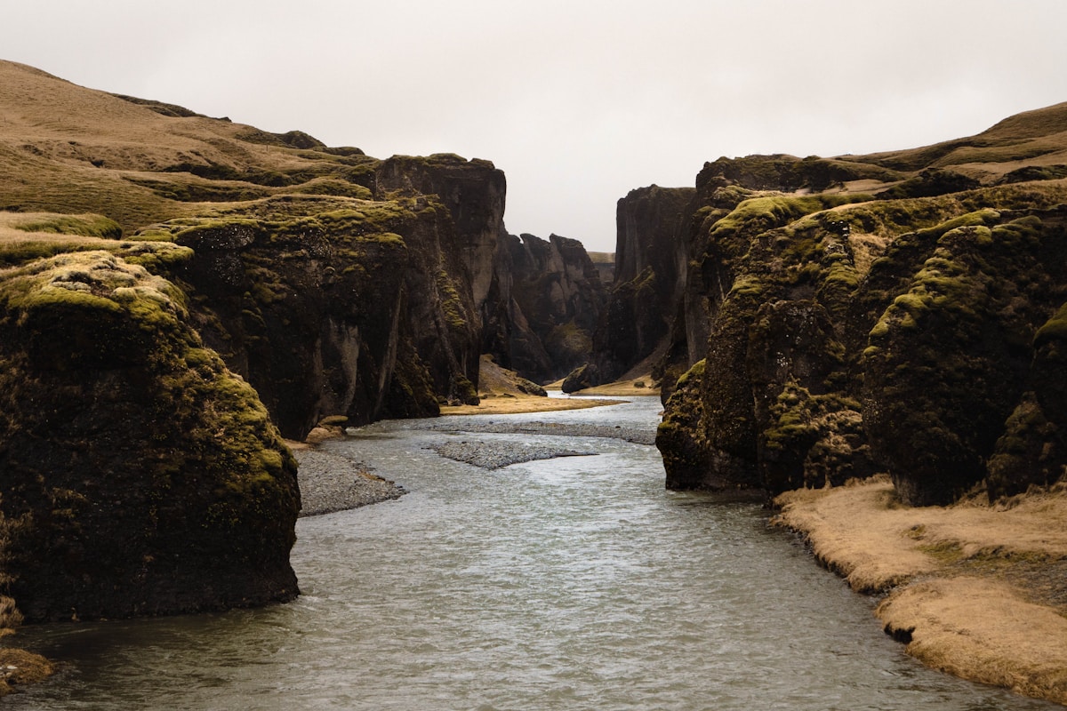
Approximately 30km east of Klaustur on Route 1, then a short turn south on Route 206 (paved). Free. One of Iceland’s most striking canyons - approximately 100m deep and 2km long, formed by glacial meltwater cutting through palagonite rock over approximately 9,000 years. The walk along the rim path takes 1–2 hours return, with multiple viewpoints along the way. The canyon is fragile and access restrictions apply to some sections - stay on marked paths. The car park is small; arriving early in summer avoids crowding.
Skaftá River and Lava Fields
The Skaftá is one of the main rivers draining Vatnajökull glacier. The view from the Ring Road bridge over the Skaftá gorge, just west of Klaustur, is notable - the river has carved deep into the older lava. The surrounding Skaftáreldahraun lava field, created by the 1783 Laki eruption, is visible from multiple points along the road. The scale of the lava coverage gives a sense of the eruption’s scale even without visiting the craters themselves.
Vatnajökull Views
From the Ring Road east of Klaustur, the edge of Vatnajökull glacier - Europe’s largest ice cap by volume - becomes visible on the horizon. Skaftafell, the most accessible part of Vatnajökull National Park for hiking, is approximately 1.5 hours east. Höfn and the Jökulsárlón glacier lagoon are approximately 2 hours. Klaustur sits at the natural transition point between the lava-dominated landscape west of here and the glacier-dominated landscape to the east.
Practical Notes
- Fuel: Fill up in Klaustur before heading east or north on F-roads. The next reliable fuel stop east is Höfn, approximately 2 hours away on the Ring Road.
- Food: Hótel Kirkjubæjarklaustur has the main restaurant in the village. There is a small N1 service station with basic food. See the Vík restaurants guide for what to expect further west.
- Accommodation: The village has Hótel Kirkjubæjarklaustur and several smaller guesthouses. Useful overflow option if Vík accommodation is fully booked.
- Pronunciation: Roughly “Kirk-ee-bigh-ar-kloys-tir” - locals will understand “Klaustur” without hesitation.
Browse Iceland tours - day trips, activity bookings, and multi-day packages across the country in one place.
Compare car hire in Iceland - a 4WD or campervan gives the flexibility to explore at your own pace.
See Also
- Kirkjubæjarklaustur travel guide - Full area overview: fuel stop, overnight base, and gateway to Laki
- Vík travel guide - 75km west: the other South Coast overnight base
- Skaftafell guide - 50km east: Vatnajökull National Park with glacier hikes and Svartifoss
- Jökulsárlón glacier lagoon - 110km east: the most dramatic stop on the South Coast
- South Coast drive - The full Reykjavík to Höfn route with Klaustur as the midpoint fuel stop
For accommodation nearby, Search hotels in Kirkjubæjarklaustur on Booking.com.