Skaftafell and Vatnajökull National Park: Hiking, Ice Caves, and Svartifoss
Book an experience
Book this activity
Lock in your preferred date. Prices shown are per person — free cancellation on most bookings.
Vatnajökull National Park covers approximately 14% of Iceland’s total land area and is Europe’s largest national park by area. At its heart, Vatnajökull glacier is Europe’s largest by volume — approximately 8,100km² of ice, in places over 900 metres thick. Skaftafell, on the park’s southern edge, is where most visitors access this landscape: a green oasis of birch woodland and hiking trails at the foot of glacial ice, with the remarkable Svartifoss waterfall at its centre.
Getting to Skaftafell
Skaftafell is approximately 326km from Reykjavík on Route 1 — roughly 3.5–4 hours of driving. The visitor centre and car park are directly off the Ring Road, clearly signposted.
From Jökulsárlón: 60km west, approximately 45 minutes. From Vík: 130km east, approximately 1.5 hours.
Parking is free. The site gets busy in July and August — arriving before 10am gives better access to parking and avoids crowded trail conditions. There is no public bus service that reliably reaches Skaftafell, though some Reykjavík-to-Höfn bus services stop at the junction.
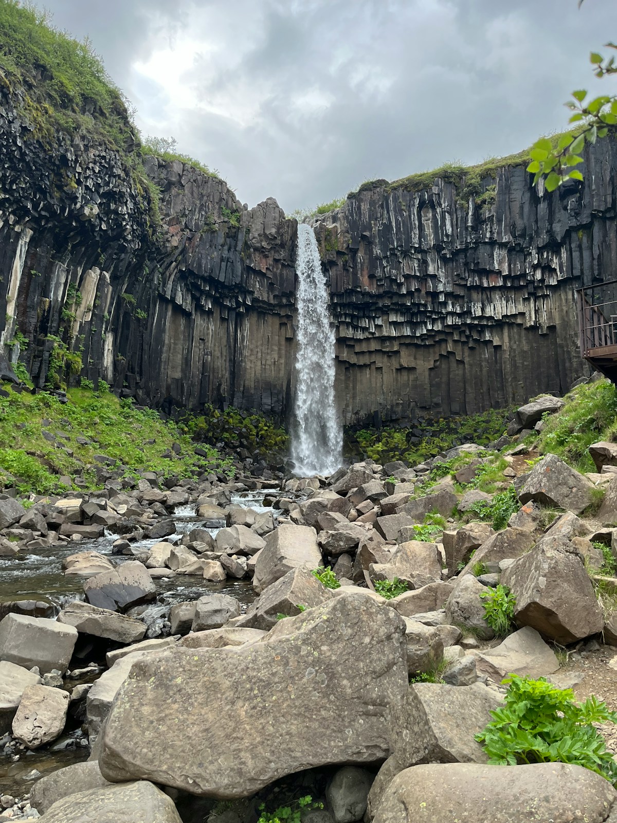
Svartifoss: The Basalt Waterfall
Svartifoss (“Black Waterfall”) is Iceland’s most visually distinctive waterfall — not because of its size (it drops approximately 20 metres) but because it is entirely framed by hexagonal basalt columns hanging from the cliff above it like a curtain of dark organ pipes. The columns are the same geological formation as those at Reynisfjara and the Giant’s Causeway in Northern Ireland: basalt that cooled slowly and contracted into regular geometric prisms.
The waterfall inspired the design of Reykjavík’s Hallgrímskirkja church — the stepped façade of Iceland’s most famous landmark echoes the basalt column structure at Svartifoss.
The hike: The Svartifoss trail begins at the visitor centre. Distance 5.4km return, elevation gain approximately 120 metres. Surface is gravel and compacted earth — walking boots are suitable. The trail is open year-round, though snow and ice in winter require caution on the upper sections.
From the waterfall viewpoint, a further 30-minute walk leads to Sjónarsker — a ridge with views across Skaftafellsjökull glacier and out over the sandur plains toward the ocean.
Skaftafellsjökull: The Accessible Glacier
Skaftafellsjökull is an outlet glacier of Vatnajökull that extends south toward the visitor centre. The glacier terminus is visible from the car park and accessible on foot in about 20 minutes on a well-maintained path. You can walk to the edge of the glacier — the point where the ice meets the moraine.
Independent viewing: Walking to the glacier edge requires no guide. You cannot walk onto the ice independently due to crevasse risk.
Guided glacier walks: Multiple operators run glacier walks from the Skaftafell visitor centre, typically departing several times daily in summer.
- 3-hour introductory glacier walk: approximately ISK 10,500–13,500 adult as of 2026
- 5–6 hour extended hike: approximately ISK 15,000–19,000 adult
- Ice climbing add-on: approximately ISK 15,000–20,000 adult
Operators include Icelandic Mountain Guides (mountainguides.is) and Local Guide (localguide.is). Equipment — crampons, helmets, ice axes — is provided.
The glacier surface shows striking blue ice sections, moulins (vertical shafts), crevasses (viewed safely from the guided route), and moraine deposits. Skaftafellsjökull has retreated approximately 500 metres since 2000 — the exposed grey bedrock around the ice edge is a direct record of that retreat.
Falljökull
Immediately adjacent to Skaftafellsjökull, Falljökull is a narrower outlet glacier visible from the Kristínartindar ridge hike. Less visited by glacier walk tours, it offers different ice formations and requires less hiking approach time. Some tour operators run small-group Falljökull glacier walks (check mountainguides.is for current availability).
Ice Caves in Vatnajökull
Natural ice caves form inside Vatnajökull when meltwater carves channels through the ice and temperatures drop in autumn, refreezing the structures into stable crystal formations. The caves are blue — the ice under this compression excludes air bubbles and absorbs red wavelengths of light, transmitting blue.
When: Mid-November through March. The caves are structurally unstable in warmer months.
Where: Most accessible from the Jökulsárlón glacier lagoon area (60km east of Skaftafell), where operators at the lagoon run daily ice cave tours. The cave locations change year to year as glacier dynamics shift — operators scout new entrances each autumn.
Cost: Approximately ISK 15,000–22,000 adult for a 2–3 hour guided tour as of 2026. Book in advance for the December–January peak period.
Operators include Glacier Guides (glacierguides.is), Local Guide (localguide.is), and Extreme Iceland (extremeiceland.is).
Extended Hikes in Skaftafell
Kristínartindar Ridge
The most challenging hike in the Skaftafell area. From the visitor centre to the Kristínartindar ridge and back: approximately 13–14km, 5–7 hours, elevation gain approximately 780 metres. Provides views of two glaciers simultaneously (Skaftafellsjökull and Falljökull) plus the Öræfajökull volcano.
Skaftafellsfjöll Loop
A 4–6 hour loop through the birch woodland above the visitor centre, connecting Svartifoss with higher viewpoints. Can be combined with the Svartifoss hike for a full day.
Trail Conditions
All trails in Skaftafell are well-marked with yellow poles. The visitor centre has current trail maps and staff can advise on conditions. Mobile coverage at the visitor centre is adequate (Síminn and Nova networks); on the higher trails it thins.
The Sandur and the Volcanic Landscape
Approaching Skaftafell on Route 1 from the west, you drive across Skeiðarársandur — a vast black gravel plain stretching between Route 1 and the ocean. This is one of Europe’s largest sandur (outwash plains): ground-up rock deposited by glacial floods over centuries. The plain is entirely flat and largely empty, broken only by remnants of the 1996 Gjálp volcanic eruption, which triggered a jökulhlaup (glacial outburst flood) that destroyed bridges on Route 1 within hours.
A surviving bridge girder is displayed at the roadside as a monument to the flood’s force.
Practicalities
Visitor centre: Open year-round, though hours are reduced in winter. Maps, trail information, and café. Rangers can advise on current glacier conditions and trail safety.
Campsite: Skaftafell campsite is one of Iceland’s largest and most popular, with hot showers, toilets, and electrical hook-ups. In peak summer, book in advance. Cost approximately ISK 1,800–2,500 per adult per night as of 2026.
Fuel: The nearest petrol stations are at Kirkjubæjarklaustur (50km west) and at Höfn (130km east). Fill up before reaching Skaftafell if your tank is below half.
Weather: The Skaftafell area sits in one of Iceland’s highest precipitation zones. Come prepared for rain and wind regardless of the forecast. The microclimate at the visitor centre is often warmer and calmer than the ring road a few kilometres east.
Browse South Coast tours — guided day trips covering Seljalandsfoss, Skógafoss, Reynisfjara, and glacier access.
Book Iceland attraction tickets — skip-the-queue entry for geothermal baths, cave tours, and top attractions.
Get travel insurance for Iceland — policies covering glacier hikes, F-road driving, and volcanic disruption.
Related Guides
- Jökulsárlón glacier lagoon — 60km east of Skaftafell: icebergs, Diamond Beach, and ice cave access
- Glacier hiking in Iceland — All glacier walking options across Iceland, not just Vatnajökull
- Ice caves in Iceland — The full guide to natural ice cave tours and when to book them
- Höfn city guide — The nearest town with full services: restaurants, accommodation, and glacier lagoon day trips
- Ring Road Iceland — How Skaftafell fits into the Ring Road circuit
Frequently Asked Questions
- How long does the Svartifoss hike take?
- The standard return hike from the Skaftafell visitor centre to Svartifoss waterfall is approximately 5.4km and takes 1.5–2 hours at a comfortable pace. The path is well-marked and maintained but involves some elevation gain (around 120 metres). An extended loop through Skaftafellsfjöll takes 4–6 hours and adds more dramatic views over the glacier.
- Do I need a guide to hike in Skaftafell?
- No guide is needed for the marked trails in Skaftafell, including the Svartifoss route and the viewpoint walks. A guide is mandatory for walking on the glaciers — you cannot access Skaftafellsjökull or Falljökull independently. Tour operators at the visitor centre run daily glacier walks.
- When are ice caves accessible in Vatnajökull?
- Natural ice caves in Vatnajökull are accessible in winter only, typically mid-November through March. Summer cave visits are possible in artificial tunnels (Into the Glacier at Langjökull), but natural Vatnajökull caves require cold temperatures to be structurally stable. Ice cave tours depart from the Jökulsárlón glacier lagoon area, approximately 60km east of Skaftafell.
- Is Skaftafell worth a separate stop or just part of a South Coast drive?
- For hikers and active travellers, Skaftafell warrants a dedicated half-day or full day. The Svartifoss hike alone is around 2 hours; combining it with a glacier walk takes 4–5 hours. If you are driving the full South Coast to Jökulsárlón, Skaftafell is a natural stop — the visitor centre is directly on Route 1.
- Is there accommodation near Skaftafell?
- Yes. Skaftafell has a campsite (one of Iceland's largest, with facilities) next to the visitor centre. The nearest village is Kirkjubæjarklaustur (50km west) with guesthouses and a hotel. Höfn is 130km east and has better hotel options. Freysnes and Fagurhólsmýri, close to Skaftafell, have small guesthouses.
Ready to explore?
Browse hundreds of tours and activities. Book securely with free cancellation on most options.
Browse on GetYourGuide →Best price guaranteed — same price as booking direct. We earn a small commission at no extra cost to you.