Þingvellir National Park: Tectonic Plates, Silfra, and Iceland's Parliament
Book an experience
Book this activity
Lock in your preferred date. Prices shown are per person — free cancellation on most bookings.
Þingvellir is where Iceland’s two defining characteristics — geology and governance — sit in the same field. The North American and Eurasian tectonic plates are visibly pulling apart here at approximately 2cm per year, opening a rift valley you can walk through. In that same rift valley, Iceland’s medieval parliament, the Althing, convened for over 900 years. Both facts deserve to be understood before you arrive.
What Þingvellir Is
Þingvellir National Park — the name means “Parliament Plains” — covers approximately 240km² in southwest Iceland, approximately 45 minutes northeast of Reykjavík by car. It is a UNESCO World Heritage Site (designated 2004) and Iceland’s only national park outside the highlands.
The site is significant for two independent reasons:
Geological: The Mid-Atlantic Ridge runs through Iceland, and Þingvellir sits directly above the rift zone where the North American and Eurasian plates are separating. The ground is literally pulling apart — the Almannagjá rift is the most visible surface expression of this. Over millennia, the rift has widened by tens of metres and the valley floor has subsided.
Historical: In 930 CE, the Althing (Alþing) — Iceland’s general assembly — was established at Þingvellir. It is one of the oldest parliaments in the world. The assembly convened at the Law Rock (Lögberg), where the Lawspeaker recited the entire legal code from memory, disputes were settled, and major decisions made. The Althing remained at Þingvellir until 1798.
Getting There
By car: Route 36 directly from Reykjavík to Þingvellir — approximately 45km, 40–50 minutes. The road is well-signposted from the capital.
On the Golden Circle: Þingvellir is the standard first stop on the Golden Circle loop. From Þingvellir to Geysir: approximately 75km east on Route 365 and Route 37, around 1 hour. From Geysir to Gullfoss: 10km, 10 minutes.
By tour: Virtually every Golden Circle tour from Reykjavík includes Þingvellir. Tours range from half-day (skipping the detail) to full-day with Silfra snorkelling add-ons.
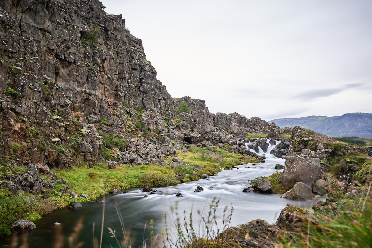
Almannagjá: Walking the Tectonic Rift
The most immediate physical feature at Þingvellir is the Almannagjá rift — a canyon approximately 7.7km long and up to 64 metres wide at points. You walk along the canyon floor between walls of basalt up to 32 metres high. The North American plate is to your right, the Eurasian plate to your left.
The main walking path through Almannagjá begins at the Hakið viewpoint (Car Park 1) and leads south to the Althing site and Law Rock. The walk takes 20–30 minutes. The rock walls are highly photogenic — dark basalt with moss, the canyon floor wide enough to allow light to penetrate.
Öxaráfoss: The Öxará River flows through the park and drops over a short waterfall — Öxaráfoss — in the canyon. Small but photogenic, particularly in early morning light. A 10-minute walk from the main Althing area.
Law Rock and the Althing Site
The Lögberg (Law Rock) is marked by a flagpole at the site where the Lawspeaker stood. The area is flat and open — the acoustics of the natural amphitheatre formed by the basalt walls meant a skilled speaker could be heard by several thousand assembled chieftains and settlers.
The medieval Althing required no buildings. Chieftains (goðar) erected temporary booths — turf and wood shelters — which are represented by small mounds visible in the grass around the site. A white church (Þingvallakirkja) stands nearby, dating from the 19th century though a church has stood on this site since approximately 1000 CE when Iceland officially adopted Christianity.
Silfra Fissure: Snorkelling and Diving
Silfra is a crack in the lake bed of Þingvallavatn, directly connected to the Mid-Atlantic Ridge rift. The water temperature inside Silfra is approximately 2–4°C year-round — filtered glacial meltwater from Langjökull glacier that has passed through lava rock for 30–100 years, removing virtually all particulate matter. Horizontal visibility in Silfra exceeds 100 metres, making it among the clearest water in the world for diving or snorkelling.
What you experience: Operators provide thick drysuits that insulate from the cold. Snorkellers float on the surface; divers descend into the fissure. The colours inside are extraordinary — deep turquoise blue water, green algae (“troll’s hair”) on the rocks, and the peculiar sensation of floating between two continents.
Booking: Tours must be booked in advance — walk-up spaces are rarely available in summer. Operators include DIVE.IS (dive.is), Arctic Adventures (adventures.is), and Dive Iceland (diveiceland.com).
Pricing as of 2026:
- Snorkelling (surface float): approximately ISK 16,000–20,000 per person for a 3-hour tour
- Diving (PADI Open Water or equivalent required): approximately ISK 22,000–28,000 per person
What to bring: Operators provide the drysuit and all equipment. Bring thermal underwear as a base layer (they will tell you exactly what is needed), warm clothes for before and after, and a swimsuit if wearing under the suit. Cameras can go in if you have a waterproof housing.
For a complete breakdown, see our dedicated Silfra snorkelling guide.
Þingvallavatn: Iceland’s Largest Natural Lake
Þingvallavatn covers approximately 84km² and is Iceland’s largest natural lake. It is visible from multiple viewpoints in the park. The lake contains four species of Arctic char that are endemic — they evolved in isolation after the lake formed at the end of the last ice age and are genetically distinct from Arctic char elsewhere in Iceland. The lake is fed by subterranean glacial meltwater and is among the clearest lakes in Iceland.
Birdlife on the lake includes various duck species and, in summer, Arctic terns. The viewing platform near Car Park 2 gives good lake views.
Longer Hikes in the Park
Þingvellir’s trail network extends well beyond the main tourist area. The lake circuit and the ridge trails above the rift valley are feasible day hikes for those with more time.
Nesgata trail: A route around the Nesjavellir geothermal area at the lake’s north end. Approximately 10km, 3–4 hours. Geothermal steam visible.
Rift wall walks: Several paths follow the top of the Almannagjá rift wall, giving elevated views along the canyon. The walk from Hakið viewpoint along the cliff edge to the northern end of the rift and back is approximately 8km, 2–3 hours.
Check the national park’s trail map (available at the visitor centre or on the park website) for current conditions, particularly in winter when snow and ice close some upper paths.
Practicalities
Parking: Car Park 1 (Hakið viewpoint and rift walk access): approximately ISK 750 as of 2026. Car Park 2 (lake and church access): similar. Car Park 5 (Silfra): separate, reserved for tour operator vehicles and booked divers/snorkellers.
Visitor centre: Located near the church. Small café and information desk. Open year-round (reduced winter hours).
Weather: Þingvellir sits at approximately 100 metres elevation. It is exposed to wind across the open rift valley and can be significantly colder than Reykjavík. Waterproof and windproof layers are standard kit even in summer.
Timing on the Golden Circle: Most coach tours arrive at Þingvellir between 9am and 11am. If driving independently, consider visiting Geysir and Gullfoss first (less morning benefit from early arrival) and arriving at Þingvellir in late afternoon when light is warmer and crowds thinner.
Frequently Asked Questions
- Is Þingvellir free to visit?
- Walking and hiking in Þingvellir National Park is free. There is a parking fee at the main car parks (approximately ISK 750–1,000 per vehicle as of 2026). The Althing site and Law Rock area are freely accessible on foot. Snorkelling and diving in Silfra require a guided tour — prices start from approximately ISK 16,000–20,000 per person.
- Can you snorkel in Silfra on your own?
- No. Silfra is within a national park and access requires a guided tour with a licensed operator. Independent entry to the Silfra fissure is not permitted. Operators including DIVE.IS, Arctic Adventures, and Dive Iceland run daily tours. A dry suit is required — the water temperature is approximately 2–4°C year-round. Snorkellers do not need a diving certification; divers do.
- How does Þingvellir fit into the Golden Circle route?
- Þingvellir is the western anchor of the Golden Circle — the 300km loop that connects Reykjavík, Þingvellir, the Geysir geothermal area, and Gullfoss waterfall. Most visitors drive the loop east from Reykjavík: Þingvellir first (45 minutes from Reykjavík), then Geysir (75km further), then Gullfoss, then back. The full loop takes 6–8 hours including stops.
- How long should I spend at Þingvellir?
- Two hours is sufficient to walk the main historical area, Law Rock, Öxaráfoss, and the rift walk along Almannagjá. A half-day (4 hours) allows a longer walk and a visit to the lake viewpoints. A full day suits hikers who want to extend into the surrounding trails. Silfra snorkelling or diving adds 3–4 hours to any visit.
- What is the best viewpoint in Þingvellir?
- The Hakið viewpoint, reached from Car Park 1 via a short walk up the cliff edge, provides the most complete overview of the rift valley, the plains, and Þingvallavatn lake beyond. This is the photograph most associated with Þingvellir — wide rift, blue lake, green plains. Go early to avoid coach groups.
Ready to explore?
Browse hundreds of tours and activities. Book securely with free cancellation on most options.
Browse on GetYourGuide →We may earn a small commission — at no extra cost to you.