Dettifoss and Northeast Iceland's Waterfalls: A Complete Guide
Book an experience
Book this activity
Lock in your preferred date. Prices shown are per person — free cancellation on most bookings.
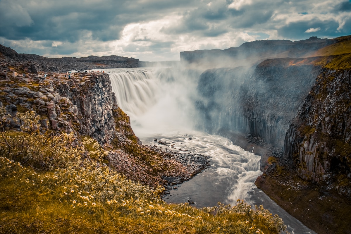
Dettifoss is Europe’s most powerful waterfall by flow rate. Approximately 193 cubic metres of water per second drop 44 metres into a basalt canyon — during peak snowmelt in June, that figure can exceed 500 cubic metres per second. The volume is not subtle. The roar is audible before the falls are visible. The mist cloud rises well above the canyon rim. You feel it in your chest.
The waterfall is on the Jökulsá á Fjöllum river in northeast Iceland — a glacial river draining Vatnajökull glacier. The surrounding landscape is the Jökulsárgljúfur canyon, part of Vatnajökull National Park’s northern section.
Getting to Dettifoss
Dettifoss is remote by Icelandic touring standards. It is not on the Ring Road (Route 1) directly — it requires a turn north from the main road and a dedicated drive of approximately 30km.
From Reykjavík: Approximately 620km by the northern route via Akureyri, or approximately 800km via the south and east. Not a day trip from the capital.
From Akureyri: 175km, approximately 2–2.5 hours via Route 1 east and Route 862 north.
From Mývatn (Lake Mývatn): 55km, approximately 50 minutes via Route 1 east and Route 862 north.
From Húsavík: 90km, approximately 1 hour via Route 85 east and Route 862 south.
Route 862 vs Route 864
Two roads reach Dettifoss from opposite sides of the canyon:
Route 862 (west side): Paved, accessible to all vehicles. Leads to the west bank viewpoint — the standard and most widely used approach. The view from the west is the one featured in most photographs and films (including Ridley Scott’s Prometheus, parts of which were filmed here).
Route 864 (east side): Unpaved gravel, can be rough and requires a high-clearance vehicle or 4WD in wet conditions. Leads to the east bank viewpoint, which is closer to the waterfall edge and gives a different angle on the cascade. Some visitors prefer the east bank for feeling closer to the water’s force.
The two sides are not connected at the waterfall — to see both, you must return to the main road and take the other route.
The Waterfall Itself
Standing at the west bank viewpoint, the scale takes a moment to process. The Jökulsá á Fjöllum is a wide, powerful, glacier-grey river above the falls — then it drops all at once, 44 metres into a canyon approximately 100 metres wide. The noise is constant and substantial. The mist cloud drifts across the canyon and over the viewpoint — at peak flow in June and July, you will get wet within a few minutes of standing at the rim.
The water is the colour of concrete — glacial silt from Vatnajökull mixed with dissolved minerals. It is not the clear water of mountain streams but the opaque, heavy grey of a major glacial river in full flood.
There is no railing or safety barrier at the canyon edge on the west side, though there is a worn viewing area. The edge is uneven and the rock is slippery from mist spray. Exercise care, particularly with children.
Selfoss: The Quieter Neighbour
One kilometre upstream from Dettifoss, Selfoss is a wider, lower waterfall on the same river. It drops approximately 10 metres but extends across much of the river’s full width — during high water, the entire Jökulsá á Fjöllum seems to spill simultaneously over a series of basalt steps.
Selfoss is significantly less visited than Dettifoss because it requires the additional 30-minute return walk from the Dettifoss car park, but the effort is worthwhile. The view down the canyon from the Selfoss viewpoint shows the scale of Jökulsárgljúfur — one of Iceland’s great canyons, carved by cataclysmic glacial floods.
Hafragilsfoss: The Third Waterfall
One kilometre downstream from Dettifoss (north), Hafragilsfoss is Iceland’s third largest waterfall by volume and accessible from the Route 862 road by a short walk. It is less visually dramatic than Dettifoss — partially hidden in a gorge — but the canyon below Dettifoss shows the geology of Jökulsárgljúfur in clear cross-section: layer upon layer of basalt from successive lava flows.
Ásbyrgi Canyon
Approximately 30km north of Dettifoss on Route 862, Ásbyrgi is one of Iceland’s most unusual geological features. A horseshoe-shaped canyon approximately 3.5km long and 1km wide with sheer walls up to 100 metres high. The floor of the canyon is unusually sheltered — birch woodland grows here that is absent from the surrounding moorland.
Norse mythology holds that Ásbyrgi was created when Odin’s horse Sleipnir struck the ground with one hoof. The geological explanation is a series of catastrophic glacial outburst floods from Vatnajökull — the most recent major flood is dated to approximately 8,000 years ago — that carved the canyon rapidly rather than through gradual erosion.
The Ásbyrgi visitor centre (open May–October) provides context on the canyon geology and on the wider Jökulsárgljúfur canyon system. A campsite operates in the canyon floor.
Walking in Ásbyrgi: A 2-hour loop trail through the canyon floor and up onto the canyon rim via fixed ladders gives excellent views into the horseshoe interior. The path to Eyjan — a small island of rock in the canyon — is the most popular short walk (30 minutes return).
Húsavík Connection: The Diamond Circle
The Diamond Circle is a loosely defined touring loop in northeast Iceland that includes:
- Dettifoss / Ásbyrgi (northeast)
- Húsavík (whale watching capital, northwest of Dettifoss)
- Lake Mývatn (geothermal area, south of Dettifoss)
- Jökulsárlón (glacier lagoon, far southeast — included in some Diamond Circle definitions)
Driving the full circuit in one day is possible but rushed. Two days allows comfortable visits to all sites.
From Dettifoss to Húsavík: Approximately 90km north via Route 862 and Route 85, around 1 hour. Húsavík has Iceland’s best whale watching with the highest probability of humpback whale sightings (June–August). See our Húsavík guide for full detail.
From Dettifoss to Mývatn: 55km south on Route 862 and Route 1, around 50 minutes. Lake Mývatn offers geothermal bathing (Mývatn Nature Baths), pseudocraters, lava formations at Dimmuborgir, and access to the Krafla volcanic system.
Practical Information
Season: Route 862 (paved, west side) is generally open May–November. Route 864 (east side, gravel) has a shorter season — typically June–September. Check road.is for current conditions before any visit.
Facilities: A basic car park and toilets on the west side at Dettifoss. No café or accommodation at the falls themselves. Bring water and food.
Nearest fuel and services: Reykjahlíð at Lake Mývatn (N1 station, approximately 55km south) and Ásbyrgi service area (approximately 30km north).
Weather: Northeast Iceland can be cold and windy even in summer. A waterproof jacket is essential at Dettifoss — the mist spray will soak light clothing within minutes at the viewpoint. Temperatures at the canyon rim can be 5–10°C lower than forecast for nearby towns.
Photography: The mist from Dettifoss is extreme at close range. A lens cloth is essential. Wide-angle lenses suit the scale of the falls. Morning light (the sun rises in the northeast in summer, catching the falls from an angle) gives the most dramatic shadows in the canyon. Selfoss photographs well in flat light when water colour is the main subject.
Frequently Asked Questions
- Which road should I take to Dettifoss — Route 862 or 864?
- Route 862 (the west side, paved) gives you the most dramatic and most photographed view — the waterfall from the west rim with the canyon behind it. Route 864 (the east side, gravel, often requiring a 4WD or high-clearance vehicle) gives a different perspective closer to the water. The west bank (862) is the better choice if you have only one visit and are in a regular car. Both sides have their own car park and viewpoint — they are not connected at the waterfall.
- How do I get to Dettifoss from Akureyri?
- Dettifoss is approximately 175km from Akureyri, around 2–2.5 hours by car. Take Route 1 east from Akureyri to Reykjahlíð (Lake Mývatn), then continue east on Route 1 and turn north on Route 862 to reach the Dettifoss west-side car park. The road to Dettifoss is open from approximately May through October — check road.is before travelling in shoulder seasons.
- Is Dettifoss included in the Diamond Circle?
- Yes. Dettifoss is one of the four main sites of the Diamond Circle — the loop in northeast Iceland that connects Dettifoss/Ásbyrgi, Lake Mývatn, Húsavík (whale watching), and the Jökulsárlón glacial lagoon in the east (some versions of the route include Seyðisfjörður). The full loop is approximately 400km and suits a 2-day itinerary from Akureyri or Mývatn.
- Can I walk between Dettifoss and Selfoss?
- Yes. A well-maintained hiking path along the canyon rim connects Dettifoss and Selfoss (about 1km south of Dettifoss). The walk between them takes approximately 30 minutes return. The canyon walls and Selfoss's wide, stepped cascade are visible from the path and from viewpoints at the Selfoss car park.
- When is the best time to visit Dettifoss?
- June through August gives the most accessible conditions and the most water volume (fed by snowmelt). The waterfall operates year-round but Route 862 and 864 are typically closed from November through April/May. Mist from the falls can be intense in summer — bring waterproof gear. Early morning visits (before 9am) are significantly less crowded in peak season.
Ready to explore?
Browse hundreds of tours and activities. Book securely with free cancellation on most options.
Browse on GetYourGuide →We may earn a small commission — at no extra cost to you.