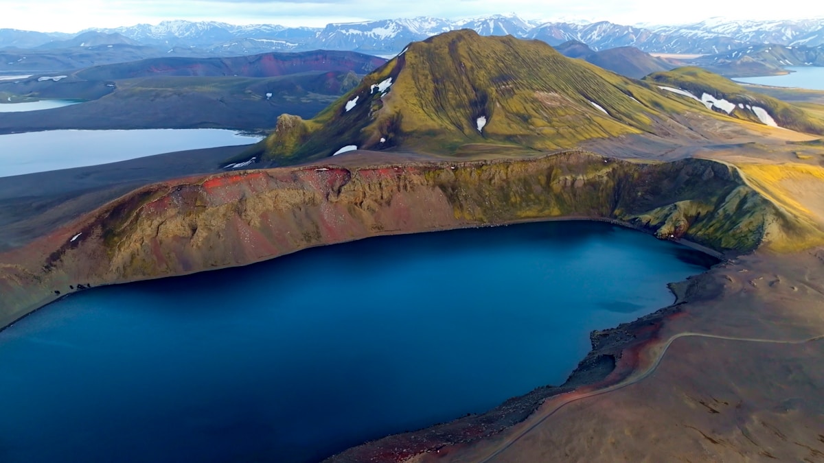
The Iceland Highlands - known in Icelandic as the hálendið - cover roughly half the island’s landmass yet hold almost no permanent human settlement. This is the country’s raw interior: a plateau of lava fields, rhyolite mountains, geothermal valleys, and glacier-fed rivers sitting at elevations between 400 and 900 metres. The roads that cross it are classified as F-roads: unpaved, often boulder-strewn tracks requiring four-wheel drive, and in several places interrupted by unbridged river crossings.
For hikers willing to make the approach, the rewards are extraordinary. The Highlands contain four of Iceland’s most compelling destinations - Askja, Kerlingarfjöll, Hveravellir, and the Landmannalaugar area - each offering a different character and a different set of walking possibilities.
When the Highlands Are Open
The highlands are a summer-only destination. F-roads open progressively from mid-June as snowmelt allows, with the last routes opening in early July in heavy snow years. Most roads close again in September, sometimes earlier if early autumn snow arrives. A few routes - the Kjölur road (F35) being the main exception - sometimes remain passable into October.
The Icelandic Road and Coastal Administration (Vegagerðin) publishes live status for every classified road at road.is. This is the only reliable source - guidebooks and apps can’t predict whether a specific river crossing is safe on a given day. Always check before driving into the interior, and always tell someone your route and expected return time.
Peak season is July and early August. Conditions are best, days are longest (continuous daylight), and highland huts are fully staffed. It’s also the busiest period - huts book out months ahead, and popular trailheads like Landmannalaugar see heavy traffic. For more solitude, late August and early September offer quieter trails with autumn colour beginning in the birch scrub.
Driving F-Roads: What You Need to Know
Vehicle requirements
A four-wheel-drive vehicle with high ground clearance is mandatory. Most mid-size SUVs (Toyota RAV4, Dacia Duster, Kia Sportage) qualify. All rental agreements in Iceland forbid taking standard 2WD cars onto F-roads - the excess liability if you do and get stuck is substantial.
Super-Jeeps (large, high-clearance 4WDs with oversized tyres) are the vehicle of choice among Icelanders for serious highland travel, particularly for routes involving deep river crossings. These can be rented from specialist operators in Reykjavík if you’re planning remote routes.
River crossings
Unbridged river crossings (called fords or vöður) are the most serious hazard on F-roads. The basic rules:
- Stop and assess before entering. Walk across if safe to test depth and current. Knee-deep is generally the upper limit for a loaded 4WD; thigh-deep for a Super-Jeep.
- Cross at the widest, shallowest point - not where the track enters, which may be where previous vehicles cut corners.
- Cross at walking pace in low gear. A steady bow wave protects the engine bay. Stopping in the river can stall the vehicle.
- Never cross alone if avoidable. Wait for another vehicle if conditions look marginal.
- Rivers run higher in the afternoon - glacial meltwater peaks 6–8 hours after midday sun. Morning crossings are generally safer.
Navigation
Download offline maps - Iceland’s interior has no mobile signal on most routes. Maps.me and the Safetravel.is app (which includes route tracking and emergency contact features) are both useful. A GPS unit or satellite communicator (Garmin inReach or similar) is strongly recommended for remote routes.
Key Destinations
Askja and the Dyngjufjöll Massif
Askja is a shield volcano in the northeast interior, accessible via the F88 or F910 roads from the Ring Road near Mývatn. The caldera contains two nested basins: the outer Askja caldera (formed in a massive 1875 eruption) and the inner Víti crater, which holds a geothermal lake of milky blue-green water.
Víti crater lake: The roughly 300-metre-wide crater contains warm, geothermal-heated water - around 25°C as of recent years, though temperatures fluctuate. Swimming is permitted and most visitors do it, but the water is milky with dissolved sulphur and the banks are steep - use the designated entry ramp, not the loose crater walls.
Öskjuvatn: Adjacent to Víti is Öskjuvatn, one of Iceland’s deepest lakes at approximately 220 metres. The lake formed after the 1875 eruption when the magma chamber partially collapsed. It’s notably cold and not safe for swimming.
Hiking at Askja: The main walk from the parking area to Víti and Öskjuvatn takes about 45 minutes each way across loose volcanic scree. Several longer routes fan out into the Dyngjufjöll massif for experienced hikers - the ridge above the caldera gives exceptional views across the central highlands. Allow a full day for the approach drive from Mývatn (around 60km each way on rough track) plus the walk.
The approach: F88 follows the Jökulsá á Fjöllum river before crossing it at Lindárbakki - this is one of Iceland’s more challenging highland river crossings. After heavy rain, this ford can become impassable. Some visitors take guided tours from Mývatn to avoid the driving entirely.
Kerlingarfjöll: Hot Springs and Highland Ridges
Kerlingarfjöll is a volcanic mountain range in the central highlands, accessible via the Kjölur road (F35). The mountains reach approximately 1,477 metres and are riddled with geothermal activity - the Hveradalir valley at the heart of the range is a landscape of steaming vents, boiling pools, and hot springs set against coloured rhyolite ridges.
Hveradalir valley hiking: The trail network from the Kerlingarfjöll mountain lodge into Hveradalir is well-marked and covers a range of difficulties. The main valley loop is around 4km, gaining about 250 metres through geothermal terrain. Longer routes continue up onto the ridges above for panoramic views across the central plateau toward Hofsjökull glacier.
The hot spring bathing area: A natural geothermal bathing pool in Hveradalir is free to use. It’s smaller and more rustic than the commercial pools elsewhere in Iceland - a flat, shallow pool fed by hot spring water, surrounded by the steaming hillside. Water temperature varies; check with hut staff on arrival.
Getting there: The Kjölur road (F35) runs between Blönduós in the north and Gullfoss in the south, passing Kerlingarfjöll at roughly the midpoint. This is one of the more accessible highland routes - the road is graded regularly and has no major river crossings, though 4WD remains mandatory. It’s a realistic day trip from the Golden Circle area.
Accommodation: The Kerlingarfjöll mountain resort operates mountain huts and camping year-round during the highland season. Book via fi.is/en or directly through the resort.
Hveravellir: The Halfway Oasis
Hveravellir sits near the midpoint of the Kjölur road, roughly 170km from Reykjavík. It’s a geothermal oasis on a vast, otherwise desolate plateau - a cluster of fumaroles, sinter formations, and naturally heated pools surrounded by nothing but open moorland and glacier views.
The natural pool: The main attraction is a geothermal pool beside the hut - a rock-lined basin of around 36–38°C, fed by hot springs. Unlike commercial pools, there’s no admission charge for hut guests. It’s one of the most atmospheric places to bathe in Iceland: sitting in 38°C water watching Langjökull glacier on the horizon.
Day hiking: Short marked trails loop through the geothermal area, passing named fumaroles including Öskurhóll (a particularly active vent) and the Bláhver hot spring pool with its vivid blue colour. The hike takes 1–2 hours.
Longer options: The Kjölur route is a classic multi-day hiking trail in its own right - Hveravellir sits at roughly the midpoint of the 5–6 day walk from Hvítárnes to Kerlingarfjöll. The full trail is less crowded than Laugavegur and passes through genuinely remote highland terrain.
Accommodation: The FÍ hut at Hveravellir has sleeping-bag beds, camping, a kitchen, and a warden on site. Book via fi.is/en well in advance for July and August.
Landmannalaugar (Highlands Access Point)
While Landmannalaugar is best known as the start of the Laugavegur trail, it’s worth treating as a highland destination in its own right. The area sits at the edge of the Fjallabak Nature Reserve, accessible via F225 (from the south) or F208 (from the Sprengisandur road).
The geothermal river at the trailhead - warm enough to bathe in, flowing through a lava field - is one of Iceland’s most unusual natural features. Day hikes from the hut include the ridge above the camp (spectacular rhyolite views) and routes into the Laugahraun lava field.
For multi-day plans, Landmannalaugar is described in detail in our Laugavegur trail guide.
Multi-Day Highland Route Suggestions
Kjölur Route (4–6 days, hut-to-hut)
The Kjölur hiking trail follows the Kjölur road corridor between Hvítárnes hut in the south and Kerlingarfjöll in the north. Intermediate stops at Hveravellir. This is a more accessible alternative to Laugavegur - no significant river crossings on foot, less dramatic but genuinely remote. Distance approximately 95km one way.
Sprengisandur Traverse (experienced trekkers, 7–10 days)
The Sprengisandur is Iceland’s central highland desert - a vast, black-sand plateau between Hofsjökull and Tungnafellsjökull glaciers. The hiking route follows the F26 road corridor from Landmannalaugar north to Mývatn. This is serious terrain: few huts, long daily distances (25–35km), and exposed conditions. Not recommended without prior highland experience and a satellite communicator.
Laugavegur + Fimmvörðuháls Combined (6–7 days)
The classic combination: Laugavegur from Landmannalaugar to Þórsmörk, then Fimmvörðuháls from Þórsmörk to Skógar. Full route is approximately 77km. This gives access to the highlands via the most spectacular section (Laugavegur) while ending on the south coast near Skógar, making logistics straightforward.
Safety and Gear
The highlands are exposed terrain. Weather changes fast - whiteout conditions are possible even in summer on the higher ground. Pack layers regardless of the forecast, and always carry:
- Waterproof jacket and trousers - rain and wind are constants
- Warm mid-layer - even July nights at elevation require insulation
- Sturdy waterproof boots - ankle support and sealed seams matter on wet lava and boggy terrain
- Map, compass, and GPS - don’t rely solely on phone reception
- Emergency bivouac - lightweight emergency shelter if you’re doing long day routes
- Food and water purification - clean stream water is available on most routes; carry a filter or purification tablets
Register your route with Safetravel.is before entering the interior and check in when you return. The platform is used by Icelandic Search and Rescue (ICE-SAR) - if you don’t return, they know where to look.
Hut Booking: fi.is/en
All FÍ-operated huts in the Highlands - including Hveravellir, Hvítárnes, and the Landmannalaugar complex - are booked via fi.is/en (Ferðafélag Íslands). Create an account, select your dates, and choose between sleeping-bag accommodation in dormitory rooms or tent pitches in the designated camping area.
Book as early as possible for July. August also fills quickly. The shoulder months (late June and early September) offer more availability but require more flexibility on weather. Kerlingarfjöll has its own booking system through the mountain resort.
Cancellation policies vary - check before booking if your dates might change.
Browse Iceland tours - day trips, activity bookings, and multi-day packages across the country in one place.
Get travel insurance for Iceland - policies covering glacier hikes, F-road driving, and volcanic disruption.
Compare car hire in Iceland - a 4WD or campervan gives the flexibility to explore at your own pace.
Related Guides
- Iceland F-roads guide - Complete guide to driving the highland roads: river crossings, vehicle requirements, and route opening dates
- Laugavegur Trail - The 55km multi-day trek from Landmannalaugar to Þórsmörk
- Landmannalaugar things to do - Activities and day hikes at Iceland’s most popular highland base
- Þórsmörk valley hikes - The southern end of the highland hiking zone: glaciers, valleys, and trail options
- Iceland car rental guide - 4WD requirements and what to rent for highland access
For accommodation before and after the trek, Search hotels in Iceland on Booking.com.